My travels to UAE and Oman in 2015 – part 2
Today I was going to visit the city of Al Ain located 120 kms south of Dubai. The fourth largest city in the UAE. Al Ain is known as the Garden City due to it greenery nature and it oasis. Al Ain is also the birthplace of Sheikh Zayed bin Sultan Al Nahyan, the first president of the United Arab Emirates.
The minibus from Dubai to Al Ain was 20 AED (£3.75) and the journey took one and half hours to two hours.
I was keen to visit the cultural sights that make up the UNESCO World Heritage Site of Al Ain. The citation of the Al Ain entry in the UNESCO World Heritage Site list describes Al Ain as having multiple locations for it citation. That being the examples of construction, agricultural use and water management in the desert since protohistory.
The designated Al Ain World Heritage Site is a serial nomination of 17 locations.
First on my sightseeing was the Al Jahili fort.

The Al Jahili fort approximately 3kms from Al Ain city centre.
The fort has no admission fees. A lone security guy sits on a chair in the shade.

Above the main entrance to the fort.
The fort is open everyday except Monday. The fort is also closed on Friday mornings.

The tower above the main entrance.
At the time of my visit, there was no other visitors and except for the lone security officer sitting on chair, I had the fort all to myself.

The main courtyard of the fort.
in the northeastern corner is the two-storey building which was used for receptions and guests of the Sheikh.

Buildings used for reception and guests of the Sheikh.
The Al Jahili fort is one if the UAE most historic buildings. It was constructed in 1891 to defend the city and protect it palm groves.

One of the towers of the fort.
In 1951, the fort was the headquarters of the Oman Trucial Scouts that protected the mountain passes and kept inter-tribal peace.

Inside the corridors of the fort.
The scouts were renamed the Union Defence Force (UDF) upon the formation of the Unitied Arab Emirates in 1971.
In the southwestern corner of the fort is the round tower.

The southwestern round tower.
The round tower consists of four concentric tiers.

The steps to the round tower.

Climbing the round tower.

Me posing in the round tower.

Me suffering in the 39 degrees heat.

The walls on the round tower.

Me posing under the round tower.
In the 1980’s the fort was handed over to the Department of Antiquities and Tourism which carried out restoration work to restore the fort to it original status.

Dates farmed inside the fort.

The bags protect the dates from beasties.
I went for a walk outside the fort.

One of the smaller towers of the fort.

Me posing in front of one of the towers.
Another restoration phase in 2007-8 by the Abu Dhabi Authority for Culture and Heritage (ADACH) saw the fort houses a Visitor Information Centre with a shop and cafe, facilities for outdoor cultural events and wider exhibition spaces.

The round tower as seen from outside the fort.

Me posing in front of the round tower.

The round tower as seen from the Al Ain garden park.
After my sightseeing at the fort I then went to the Al Ain Palace Museum.

The main garden in the courtyard of the palace.
The palace is the former home of the late UAE founder, Sheikh Zayed Bin Sultan Al Nahyan.

One of the wall towers of the palace.
The palace was built in 1910 and in 1998 the palace became a museum.

Inside one of the reception rooms.
The palace has no admission fees.

Wall decoration.
The Al Ain Oasis is the largest oasis in Al Ain. The oasis is 3000 acres and contains over 147,000 dates palms.

Pathways inside the oasis.
It was easy to get lost inside the oasis.

One of the farms inside the oasis.
The oasis is known for its underground irrigation system “falaj” which brings water from boreholes to water farms and palm trees.

Dates growing in one of the palm plantations.
The falaj irrigation is an ancient system dating back thousands of years.

As with the fort, the dates were bagged.
Other crops grown here are mangoes, oranges, bananas and figs.

Dates is exported around the world from here.
Inside the oasis there are remains of an old fortification and an mosque.

Palm tree silhouette.
Heading back into the city centre, I passed the mosque.

The main mosque in Al Ain.

Al Ain Mosque silhouette.
I decided to go to the market.

Inside the market.
An assortment of fresh fruit and meat is available here.

Fresh fruit from the market.
Next on my sightseeing was to visit the Al Ain National museum.
Al Ain National museum is the oldest museum in the UAE. Opened in 1971, the museum features displays on the city’s exclusive heritage and history.
The museum is housed in the same compound as the Sultan Bin Zayed Fort (also known as the Eastern Fort) which was built in 1910 and is well conserved.
The museum is 3 AED (£0.60) admission. As with other attractions in Al Ain, the museum is close on Mondays and closed on Friday mornings.

The fort was built in 1910.
The Eastern fort was constructed a 100 years ago by Sheikh Sultan bin Zayed Al Nahyan and served as a residence to his family since then and until he succeeded as the ruler of Abu Dhabi in 1922.

The main entrance to the fort.
It was converted to a museum and opened to the public in 1971.

One of the cannons at the entrance of the fort.
The fort is quite small and is only 35 metres in length on each side.

One of the towers.
After my sightseeing, it was time to head back to Dubai and my luxury *ahem* hotel.
Tomorrow, I was going to go scuba diving on the east coast of UAE and Oman.
To be continued….
For more information about the UAE please visit:
My travels to Greece in 2014 – part 2
Today I was going to visit the Acropolis of Athens, a World Heritage Site listed by UNESCO.
The Acropolis of Athens is an ancient citadel located on a high rocky outcrop above the city of Athens and contains the remains of several ancient buildings of great architectural and historic significance, the most famous being the Parthenon.

Acropolis of Athens is a World Heritage Site.
While there is evidence that the hill was inhabited as far back as the fourth millennium BC, it was Pericles (c. 495 – 429 BC) in the fifth century BC who coordinated the construction of the site’s most important buildings including the Parthenon, the Erechtheion and the temple of Athena Nike.

I was taking in the sites.
It cost 12 Euros to visit all six sites of the Acropolis of Athens and the ancient Agora.

Another UNESCO World Heritage Site ticked off on my bucket list.
The slopes of the Acropolis has many statues and monuments.

This poor fellow lost his arms.
The theatre of Dionysus is at the base of the Acropolis and it was used for festivals in honor of the god Dionysus. It has seating for 17,000 spectators.

The Theatre of Dionysus is an open-air theatre and one of the earliest preserved in Athens.
The Parthenon is a former temple dedicated to the goddess Athena, whom the people of Athens considered their patron.

The Parthenon is a former temple.
The Erechtheion is an ancient Greek temple on the north side of the Acropolis of Athens in Greece which was dedicated to both Athena and Poseidon.

The Erechtheion is an ancient Greek temple on the north side of the Acropolis.
On the north side, there is another large porch with six Ionic columns, and on the south, the famous “Porch of the Maidens”, with six draped female figures (caryatids) as supporting columns.
In 1801 one of the caryatids and the north column of the east porch together with the overlying section of the entablature were removed by Lord Elgin in order to decorate his Scottish mansion, and were later sold to the British Museum (along with the pedimental and frieze sculpture taken from the Parthenon). The new Acropolis Museum holds the other five figures, which are replaced onsite by replicas.

The Erechtheion is a temple dedicated to both Athena and Poseidon.
From atop I could see all across Athens including the ancient Agora down below.

The view from the top.
The ancient Agora was the central spot in ancient Athens. The Temple of Hephaestus is located at the north-west side of the Agora.

The Temple of Hephaestus is a well-preserved Greek temple.
The ancient Agora has a small museum.

This statue was proudly showing off.
I headed to a viewpoint to look across the ancient Agora.

Looking over the ancient Agora.
It was mid-November and warm enough for me to wear t-shirt and shorts.

Looking across the ancient Agora to the Acropolis.
Next on my sightseeing was the Panathenaic Stadium. The stadium is a multi-purpose stadium used for several events and athletics and hosted the first modern Olympic Games in 1896. Reconstructed from the remains of an ancient Greek stadium, the Panathenaic Stadium is the only major stadium in the world built entirely of white marble.

The Panathenaic Stadium hosted the first modern Olympic Games in 1896.
In the 2004 Olympic Games, the Panathenaic Stadium hosted the archery competition and the finish of the Marathon.
It could once seat about 80,000 spectators on fifty rows of marble steps and currently holds 45,000 spectators.

It cost 3 Euros to visit the stadium.
The next day, I headed to the mountains surrounding the city of Athens. I came across a wild tortoise in the forest.

A wild tortoise.
The Kaisariani Monastery is an Eastern Orthodox monastery built on the north side of Mount Hymettus, near Athens.

The Kaisariani Monastery is just outside Athens.
The monastery was probably established in Byzantine times in ca. 1100.

It is high up in the mountains within the forest.
I took the metro back to Athens city centre.

Graffiti is everywhere in Athens.
Shopping in Athens is a favorite pastime for tourists and Athenians and one of the best places to buy just about anything is the Monastiraki Flea Market.

The many stalls of Monastiraki Flea Market at Avissynias Square.
After my shopping I headed to the marina on the coast.
I was invited by the Qatar’s former Prime Minister Hamad bin Jassim bin Jaber Al Thani to have dinner on board his supersize yacht (that was probably paid for by taxes and corruption). At dinner we discuss FIFA 2022 World Cup bribery and rigging. We decided that Germany will win the cup in 2022. The Al Mirqab yacht is one of the largest motor yachts ever built at a length of 133 metres. The yacht is normally moored at the Faliro coastal area of Athens.

The Al Mirqab yacht belongs to former Qatar’s Prime Minister Hamad bin Jassim bin Jaber Al Thani.
It was time to head back to Britain and to put up my Xmas decorations.

The sun sets over Athens.
– The End –
For more information about Greece please visit:
My travels to Greece in 2014 – part 1
After a hard few months drilling my troops on the parade square, the Colonel has given me a weeks leave. My Auntie decided that we should go to Greece for some winter sun.
I arrived in Athens, the capital of Greece. Athens is one of the world’s oldest cities, with its history spanning around 3,400 years. It was a somewhat hot day with temperatures of 21 degrees and blue skies so I was looking forward to stripping down to my speedos when we hit the beach phwwooaarr…. I made sure that I had my speedos packed as I wanted to flash my assets to the greek gals.

The flag of Greece.
My first tourist attraction was the Parliament building just off Syntagma Square and to inspect the soldiers at the Tomb of the Unknown Soldier.

The Tomb of the Unknown Soldier.
The guards stand in front of the Tomb of the Unknown Soldier.

These guards stood motionless even after I had farted!
The elite Evzones light infantry unit, provide a 24-hour honor guard, with an hourly guard change.

Not even a blink!
The Changing the Guard at the Tomb of the Unknown Soldier in particular has become a tourist attraction, with many people marvelling at the guards, who stand motionless during their one hour shifts.

They change the guards on the hour.
On the way back to my hotel, I stopped by one of the many sex shops that are in Athens.

I stocked up my porn DVD collection.
The next day my Auntie took me island hoping and the chance to enjoy some winter sun. We took the ferry to the island of Aegina 17 miles (27 km) from Athens. It was a really hot day and definitely a day for sunbathing and sexy gals.

The sea was so calm, definitely a day for swimming.

From the ferry I could see the Temple of Apollo.

Coming into port.
Aegina is a small island and it is the nearest island to Athens and so it is popular vacation place for the Greeks especially in the summer.

Old fishing boats in Aegina harbour.
Aegina town has many side streets for a pleasant walk.

The cathedral of Saint Nectarios of Aegina.

Olives growing on trees.
Aegina is famous for it pistachio nuts. A 500g bag of nuts cost 6 Euros.

A pistachio nuts stall.
Before we headed to the beach, my Auntie wanted us to see the Temple of Apollo.

The ruins of the ancient settlement.
This temple is only a short walk from the port.

I was taking in the sights.
It cost only 2 Euros to visit the ruins.

This temple is dated from 600 B.C.
It was built in the 6th century B.C. and only one pillar is left from the temple.

Only one pillar remains in the ancient sanctuary.
I could not believe how hot it was and so off to the beach we went….

What a beautiful day it was.
….and the beach was quiet too!

The beach was quiet and we had it all to ourselves.
I slapped on some suncream and eager waited for my Auntie to strip to her bikini…. Then disappointment – she had forgotten her bikini. Oh well naked sunbathing was in order. Then more disappointment grrrr…. nude sunbathing is illegal in Greece. Boo hoo….

It was great to strip off on the beach.
We headed back to the ferry port just after sunset for our trip back to Athens.

Sunset over Aegina Town.
Tomorrow I was going to visit the Acropolis of Athens, a World Heritage Site.
To be continued….
For more information about Greece please visit:
My travels to Morocco in 2014 – part 1
I have just come back from a trekking expedition in the Atlas Mountains in Morocco.
This is not the first time that I have been to Morroco as my previous blog shows:
https://britisharmysgtmonkey.wordpress.com/2012/02/19/my-night-the-desert-with-a-berber-tribe/
I was aiming to climb the highest mountain in the Atlas Mountains and also the highest mountain in North Africa.

A map of Morocco showing Mt. Toubkal.
The mountain in question was Mt. Toubkal at 4167m. It is located 63 km south of the city of Marrakesh, in the Toubkal National Park, and is a popular destination for climbers. Toubkal National Park was established in 1942, it covers an area of 380 km2. The first known ascent by Europeans was on 12th June 1923 by the Marquis de Segonzac, Vincent Berger and Hubert Dolbeau.
The mountain is not technical for climbing however it is steep and the ascent is hard going. During the winter, the mountain is icy and thus crampons and winter climbing skills are needed.
I flew into Marrakesh airport that is now served by budget airliners from the UK. However, I decided to fly business class as I am somewhat special.

Flying over the desert.
After checking into my hotel I went over the map again to make sure that I knew where I was going.

I was studying my proposed route on the map.
I decided to spend a few days here to look at the sights and sounds of Marrakesh.
First on my wishlist was to see the Jemaa el-Fnaa square. It is part of the city’s medina that is a UNESCO World Heritage Site.

The Jemaa el-Fnaa square with the Moroccan flag.
The square and market place is in Marrakesh’s medina quarter known as the old city.

The Jemaa el-Fnaa square during the day.
It remains the main square of Marrakesh, used by locals and tourists.

The square is full of activity.
Here one can buy fossils, souvenirs, carpets and other tack. Snake charmers and dancers here demand money for souvenir photos.

The square is the centre of Old Marrakesh.
Shortly before noon on 28th April 2011, a blast originating in a cafe in the square killed 17 people and injured another 25. It is thought that it was a bomb attack.

Many tacky sourvenirs can be haggled over here.
I brought myself 7kgs of fossils although I think some of them are cement fakes.

The souk in the medina.
I also got my auntie a tagine cooking pot for her birthday.

Olive stalls in the market souks.
You can easily get lost in the medina.

My dinner being delivered to my hotel.
Koutoubia Mosque is the largest mosque in the city. It was completed under the reign of the Almohad Caliph Yaqub al-Mansur (1184-1199).

Koutoubia Mosque is the largest mosque in Marrakesh.
The mosque is closed to non-muslins.

The mosque is near the square.
The minaret is constructed from sandstone and stands 77 metres (253 ft) high.

The minaret stands over the city.
Next was to visit the city walls. The ramparts of Marrakesh stretch for some 12 miles (19 kms) around the medina of the city,

The old city walls of Marrakesh.
They were built by the Almoravids in the 12th century as protective fortifications for the city.

The walls were impressive.
It was now evening time so I decided to go for a swim at my hotel.

Relaxing at the pool.
The sun was going down.

Enjoying the sunset.
I headed back to the square for dinner.

Having snails for my dinner.
The sun sets over the city for the next day I was to head to the mountains.

The sun sets over Marrakesh.
I need an early night for tomorrow I was heading to the mountains.
To be continued….
For more information about Morocco please visit:
My travels to Russia in 2014 – part 5
For my rest of my trip to Russia I was going to fly from Moscow to Saint Petersburg.

On the plane to Saint Petersburg.
It is located on the Neva River at the head of the Gulf of Finland on the Baltic Sea. It is Russia’s second largest city after Moscow with 5 million inhabitants.
Saint Petersburg was founded by Tsar Peter the Great in 1703.

The Bronze Horseman, monument to Peter the Great.
The historic centre of Saint Petersburg constitute a UNESCO World Heritage Site. The city has 221 museums, 2000 libraries, more than 80 theaters, 100 concert organizations, 45 galleries and exhibition halls, 62 cinemas and around 80 other cultural establishments – obviously I was not going to see all of them.
Saint Petersburg is also home to the Hermitage, one of the largest art museums in the world. It was founded in 1764 by Catherine the Great in 1764 and been opened to the public since 1852.

Me at the Hermitage.
The collections occupy a large complex of six historic buildings along Palace Embankment, including the Winter Palace, a former residence of Russian emperors.

The entrance to the Winter Palace.
Its collections comprise over three million items including the largest collection of paintings in the world.
Next on my sightseeing was the Church of the Savior on Blood. This Church was built on the site where Tsar Alexander II was assassinated and was dedicated in his memory.
The Church is situated along the Griboedov Canal.

Construction began in 1883, work was finally completed in 1907.
Construction began in 1883 under Alexander III, as a memorial to his father, Alexander II. Work progressed slowly and was finally completed during the reign of Nicholas II in 1907.

Me admiring the domes.
The church never functioned as a public place of worship, having been dedicated to the memory of the assassinated tsar. The church is now one of the main tourist attractions in St. Petersburg.

Detail of the richly decorated façade and onion domes.
The Church contains over 7500 square metres of mosaics.
During the Russian Revolution, the church was ransacked and looted. During WW2 the church suffered significant damage. It has now been restored.

Inside the church.
The next day I was going visit the sites of the Russian Revolution.
To be continued….
For more information about Russia please visit:
My travels to Russia in 2014 – part 3
For my next day in Moscow, I was going to so some sightseeing inside the Kremlin. The Kremlin is just to the west of the Red Square. The complex serves as the official residence of the President of the Russian Federation. The Kremlin together with the Red Square is a UNESCO World Heritage Site.

View of the Kremlin from the Moskva River.
Within the walls of the Kremlin are five palaces and four cathedrals.

Cannons outside one of the palaces.
Cathedral Square is the heart of the Kremlin.

Me in Cathedral Square.
The square is surrounded by six buildings, including three cathedrals.

One of the four cathedrals inside the Kremlin.
The Ivan the Great Bell Tower with a height of 81 metres (266 ft). The bell tower today contains 22 bells. Until the Russian Revolution, it was the tallest structure in Moscow, as construction of buildings taller than that was forbidden.

Me posing next to the bell tower.
The largest bell in the world, the Great Uspensky Bell, or the Tsar Bell, stands at the foot of the Ivan the Great Bell Tower.

The largest bell in the world, the Great Uspensky Bell.
It weighs 65.5 tons
My next scheduled meeting with president Putin at the peace talks went well. After giving Putin my auntie’s homemade cookies he began to open up in our discussions on peace. He said he might pull troops out of the Crimea if in exchange we can swop the Crimea in exchange for part of the UK! So that had me thinking what part of the UK do I trade for in exchange for the Crimea…. mmm…. maybe the Shetlands? I will have to phone the prime minister tonight.
After the meeting, Putin decided to take me to MacDonalds for dinner.
In 1988 McDonalds got permission from the Communist Party of Soviet Union to open its first restaurant in Soviet Russia and so in 1990 the first MacDonnalds opened up.

The best restaurant in Moscow?
People from all over Russia wanted to visit this “pearl of the capitalism” so there were literary a mile long line of the visitors to this place.

Lots of funny writing on the menu.
Mind, the beefburgers doesn’t taste any better here than it does in the Western world.
To be continued….
For more information about Russia please visit:
My travels to Russia in 2014 – part 2
For my second day in Moscow I was going to visit the Novodevichy Convent. This convent remained virtually intact since the 17th century and so in 2004, it was proclaimed a UNESCO World Heritage Site.

Novodevichy Convent is a UNESCO World Heritage Site.
The convent was founded in 1524 by Grand Duke Vasily III to celebrate the recapture of Smolensk from the Lithuanians.

The entrance to Novodevichy Convent.
The convent was built as a fortress at a curve of the Moskva River.

A tower on the walls of the convent.
The oldest structure in the convent is the six-pillared five-domed cathedral, dedicated to the icon Our Lady of Smolensk.

The cathedral dedicated to the Our Lady of Smolensk.
Extant documents date its construction to 1524–1525. Most scholars agree that the cathedral was rebuilt in the 1550s or 1560s.

Me posing in front of the Cathedral of Our Lady of Smolensk.
In 1922, the Bolsheviks closed down the convent but the nuns returned in 1994.

The cathedral was built at the Convent’s founding.
The domes were added a century after the cathedral construction.

One of the five domes on the cathedral.
In 1812, Napoleon’s army made an attempt to blow up the convent, but the nuns saved the convent from destruction.

It was a clear sunny day for my visit.
Other buildings of note includes the red and white Church of the Assumption and the neighboring refectory, the soaring bell-tower and the north and south gate churches.

Other buildings in the convent includes the Church of the Assumption.
The bell-tower was built to a height of 72 metres (236 ft), making it the tallest structure in 18th-century Moscow (after the Ivan the Great Bell Tower in the Kremlin).

The octagonal bell-tower.
The convent is also famous for its cemetery, which is the final resting place for a number of Russian cultural and political figures, including Chekhov and Shostakovich.
The cemetery was designed by Ivan Mashkov and inaugurated in 1898.

Novodevichy Cemetery is next to the convent.
Famous Russians buried here includes Borris Yeltsin (1931-2007). The first post Soviet era president.

Boris Yeltsin monument at Novodevichy Cemetery.
Boris Yeltsin was the first freely elected President of Russia serving 1991 to 1999. He voluntarily resigned from the post in 1999, leaving the job to Putin.
After visting the convent and the cemetery I went for a walk in the park outside the convent. It was a clear sunny day but the lake was still frozen from the winter.

The lake was frozen.
After my sightseeing I was scheduled to meet president Putin for the second round of talks in the peace confernece that I was hosting over the Ukraine crisis. After the poor start to my first meeting with the president in which he poured a jug of water over me, I decided that I need to be more diplomatic for the second round of talks. Before I flew out to Russia, my auntie gave me a tin of homemade cookies. Mmmmm….. so what if I give president Putin the homemade cookies? Maybe he would more opening with peace discussions.
So anyway, I arrived at the Kremlin (via the back door) and the peace talks began. Putin was very impressed by my auntie’s homemade cookies and he offered me a vodka. We began talking on the serious matter at hand that is the Ukraine and the Crimea crisis. President Putin said that he was not going to change his stance to a cuddly toy negotiator. Oh well…. maybe better success tomorrow with the peace talks.
To be continued….
For more information about Russia please visit:
My travels to Russia in 2014 – part 1
Yesterday, I flew back from Moscow in Russia. I spent eight days in Russia as the head negotiator of a Unitied Nations peace talks to discuss the Crimea crisies with president Putin. Would he listen to the monkey? I also had time to do some sightseeing in both Moscow and Saint Petersburg.
It was cold when I flew into Moscow but not as cold as I was expecting.

Arriving at Moscow’s Domodedovo Airport.
After checking into my hotel, I headed to the Red Square.

Me at the entrance to the Red Square.
The Red Square is the heart of Moscow and together with the Kremlin was recognized as a UNESCO World Heritage Site in 1990, due to their inextricable links to Russian history.
The buildings surrounding the Square are all significant in some respect. Lenin’s Mausoleum, for example, contains the embalmed body of Vladimir Ilyich Lenin, the founder of the Soviet Union.

The Red Square is the heart and soul of Russia.
The Red Square get its name from the Russian word красная (krasnaya) which can mean either “red” or “beautiful”. It is the latter that implies the Red Square. Many tourists falsely thinks the Red Square get its name from the red walls of the surrounding Kremlin walls.

Me in the Red Square.
The Red Square hosts the annual military victory day parade. Russian military vehicles are paraded through the square. Last years parade is here:
https://www.youtube.com/watch?v=UjeW74XcAvc
Next on my sightseeing was to visit the Kazan Cathedral on the northeast of the Red Square. This is a reconstruction of the orginal cathedral built in the 17th century.

Kazan Cathedral was rebuilt in 1993.
The orginal cathedral was destroyed in 1936 under orders of Stalin.

The cathedral is very pretty.
The new building is an exact copy of the orginal cathedral.
Next on my visit was the Tomb of the Unknown Soldier on the walls of the Kremlin just next to the Red Square. This tomb contains the remains of unknown soldiers killed in the Battle of Moscow 1941.

The Tomb of the Unknown Soldier is dedicated to the Soviet soldiers killed during World War II.
Since 1997, a Guard of Honour of the Kremlin Regiment guards the tomb.

The changing of the guards takes place on the hour.
The Tomb of the Unknown Soldier was unveiled to the public on May 8th 1967.

The soldiers perform their movements in synchronize steps.
The changing of the guards attracts a large tourist crowd.

I then inspected the guards.
Next on my visit of the Red Square was Saint Basil’s Cathedral. It is no longer a church but now a museum.

The Cathedral of Vasily the Blessed, commonly known as Saint Basil’s Cathedral.
As part of the program of state atheism, the church was confiscated from the Russian Orthodox community as part of the Soviet Union’s anti-theist campaigns and has operated as a division of the State Historical Museum since 1928.

Me admiring Saint Basil’s Cathedral.
After visiting the cathedral I went to the exclusive shopping mall next to the Red Square known as the Glavnyi Universalnyi Magazin (GUM). With the collapse of communism, nowadays the GUM is very exclusive and the rich and famous shop here for top end fashions and jewellery.

Glavnyi Universalnyi Magazin (GUM) known as the State Department Store.
I was looking at the exclusive yellow diamonds at Tiffany and Co. I was considering getting my auntie a yellow diamond pendant. I was quoted 14,000 Euros. On my army salary I will have to save a while.
It was now getting dark and I wanted to see the Red Square at night. The colour scheme of Saint Basil’s Cathedral is best seen by night.

Saint Basil’s Cathedral at night.
After dinner, I went to the Kremlin for my first meeting with President Putin. I told him that he must not invade the Ukraine. He then pour his glass of water over my cotton fur and walked out of the conference. I have to be more diplomatic tomorrow at the next scheduled meeting.
With my failure at the first day of the peace talks, I decided to get drunk and visit a brothel.

I went to a exclusive gentlemen’s club.
To be continued….
For more information about Russia please visit:
My travels to Portugal in 2013 – part 2
After a wild night drinking cherry liqueurs and partying with the girls today I was going to go to Belém. This district is famous as the place from which many of the great Portuguese explorers set off on their voyages of discovery. It is a UNESCO World Heritage Site because of its history and has many attractions such as the Torre de Belém, and the Mosteiro dos Jerónimos (Jerónimos Monastery).
My first attraction was the National Palace of Belém which have previously been the official residence of Portuguese monarchs. It is now the residence of the president of the Portuguese Republic.

The ceremonial guard at the entrance to the palace.
At the National Palace of Belém I was eager to inspect the guards to see if they match the standards of my own troops.

I inspected this guard.
On the wateredge is the Padrão dos Descobrimentos (Monument to the Discoveries).

The Monument to the Discoveries.
Located along the Tagus River where ships departed to explore and trade with India and Orient, the monument celebrates the Portuguese Age of Discovery during the 15th and 16th centuries.

The monument features 33 statue figures.
The main statue on the monument is of Henry the Navigator, holding a model of a carrack. On either side of the ramps of the monument are a total of 33 figures from the history of the Discoveries.

I was glad to have my photo taken at this World Heritage Site.
This monument was inaugurated on 9 August 1960.

The globe represents the Age of Discovery.
The monument is a popular tourists attraction.

This was the site that Portuguese explorers departed.
For 3 Euros tourists can take the lift up to the top of the monument.

The bridge across the Tagus River can be seen.
From the top views of the Tagus River, the Belém neighbourhood and its many attractions, including the Belém Tower and the Jerónimos Monastery.

I could see for miles.
It was windy up here for my cotton hair.

Belém Tower can be seen in the distance.
The viewing platform is six stories high.

The Monastery of the Jeronimos can be seen across the gardens.
The monastery was classified in 1983 as a UNESCO World Heritage Site, along with the nearby Tower of Belém.
Originally, the home for the Hieronymite religious order, was built by Henry the Navigator around 1459.
The monastery withstood the 1755 Lisbon earthquake without too much damage.
In 2007, the Treaty of Lisbon was signed at the monastery, laying down the basis for the reform of the European Union.
Next on my sightseeing was the Belém Tower. The Torre de Belém was built party to defend the monastery and guard the entrance to the port.
It was built in the early 16th century. The tower was commissioned by King John II to be part of a defence system at the mouth of the Tagus river.

The tower defends the entrance to the port.
The tower is on the registry of the Seven Wonders of Portugal. This list is of the cultural wonders located in Portugal and was compiled by the Ministry of Culture.

Me posing in front of Belém Tower.
It cost 5 Euros to go inside the tower. Because of the single narrow staircase to the top of the tower, the authorities operates a traffic light system for climbing the stairs to avoid conjestion. Not all tourists follows this and jams do occur.

The traffic lights system to control the flow of the tourists.
My sightseeing was over and time for a quick beer or two before heading to the airport and back home to the SAS special forces barracks.

This cafe was a traditional yellow tram.
Back to work with the special forces and secret missions behind enemy lines.
For more information about Lisbon please visit:
My daytrip to Mostar, Bosnia and Herzegovina in 2013
Today I was going to go onto another daytrip minibus tour. This time I was crossing the border into Bosnia and Herzegovina and in particular to the city of Mostar.
The last time I was in Bosnia and Herzegovina was during the 1990’s civil war when the British Army was deployed on UN and later the NATO SFOR operations. It was no place for a young 4 year old cuddly toy that I was back then.
An old photograph of me on peacekeeping UN duties serving in Bosnia in 1992.

I am the one driving the Warrior armoured personnel carrier.
I was awarded a medal for my peacekeeping duties.

Me proudly wearing my SFOR medal for service to peacekeeping.
Mostar is famous for the Old Bridge, built by the Ottomans in the 16th century and is one of Bosnia and Herzegovina’s most recognizable landmarks. The Old Bridge and its vicinity are listed by UNESCO onto the World Heritage Sites List.
During the 1991-95 civil war, the old bridge was destroyed by Croat forces. However, a new bridge was reconstructed after the war and this was opened in 2004. Prince Charles opened the new bridge.
This video footage is of the destruction of the Old Bridge in 1993.
With funding from the international community, a new bridge was built after the war.
As with minibus tour yesterday, Pauevnic Roaiski was to be my tour guide. It was a three hour drive from Dubrovnik to Mostar but we did stop in Počitelj just over the border into Bosnia and Herzegovina for a little half way stop. The historic site of Počitelj is located on the left bank of the river Neretva, the same river that Mostar stands on.

Počitelj has a mix of medieval and Ottoman architecture.
The old fortifications of the town were built in 1383.

Me posing with Počitelj Tower in the background.
Počitelj tower stands over the town and was built during the medieval peroid.

Počitelj Tower stands over the town.
The influence of the Ottoman Empire is evident in this town.

Počitelj mostly has an islamic population.

I was exploring the town.
We stayed here for thirty minutes before heading to Mostar.

The mosque that stands in Počitelj.
Back on the road to Mostar, I recall to the tourists on the minibus my service in Bosnia and Herzegovina during the war. They were very impressed by how brave a cuddly toy I was.
Upon arrival into Mostar, I could see both damage from the war as well as newly constructed buildings.

The evidence of war still remains.

The Old Town has been completed rebuilt.
The Old Town is very popular with tourists on daytrips from Dubrovnik.

The main street of the Old Town.
Mostar is very popular with tourists now, most of who are daytrippers from Dubrovnik.

It was very busy with tourists.

The Old Town and bridge is a World Heritage Site.
I was glad to return to Bosnia and Herzegovina since the war had ended in 1995.

Me in Bosnia for the first time since the war ended.
Since the end of the civil war in 1995, great progress has been made in the reconstruction of Mostar.

The bridge has been rebuilt.
The bridge was opened in 2004.

The bridge looked just like the Old Bridge destroyed in 1993.
These days, a popular tourist attraction is watching local dive off the bridge into the river. It is a 25 metre drop. The locals divers charge tourists 30 Euros for them to dive off and to allow tourists to video record them.
Of course some tourists dive off the bridge themselves and get their mates to video record it (for free!)
However, one must jump on the correct side of the bridge so that they will not be jumping/diving off into shallow water as has happened already this year to one unlucky tourist.

I posed next to the Old Bridge.
After three hours of sight seeing and buying tacky souvenirs, I returned back to Dubrovnik for some ice cream and girls.
The next day I was flying back to the UK and back to work with the British special forces.
For more information about Bosnia and Herzegovina please visit:
My daytrip to Kotor, Montenegro in 2013
Today, I was leaving Dubrovnik for a daytrip to Kotor just across the border in Montenegro. I was going on a tour minibus with a guide named Pauevnic Roaiski.
Montenegro is a former Yugoslavia state and it has a coast on the Adriatic Sea and is bordered by Croatia to the west, Bosnia and Herzegovina to the northwest, Serbia to the northeast. Its capital and largest city is Podgorica, while Cetinje is designated as the Prijestonica, meaning the former Royal Capital City. It became independent of Yugoslavia on 2006. It is a small country with a population of just 625,000 people.
The tour bus cost 40 Euros and our guide was very knowledgeable. It is a two and a half hours drive to Kotor – a World Heritage Site on the UNESCO list.

My passport stamp from Montenegro.
The old Mediterranean port of Kotor is surrounded by fortifications built during the Venetian period. It is located on the Bay of Kotor, one of the most indented parts of the Adriatic Sea. Some have called the southern-most fjord in Europe, but it is a ria, a submerged river canyon. Together with the nearly overhanging limestone cliffs, Kotor and its surrounding area form an impressive and picturesque Mediterranean landscape.
In recent years, Kotor has become very touristy due to day trippers from Dubrovnik.

The Old Town is surrounded by the walls.
As my guide said, some 90% of tourists are from either cruise ships or day tours from Croatia.

I was taking in all of the sights.
In World War I, Kotor was one of three main bases of the Austro-Hungarian Navy.

Me admiring the city walls.
The Old Town has been fortified many times over the years.

The hilltop fortifications can been seen.
Kotor was first recorded in 168 BC as a Roman settlement.

The walls of the Old Town.

The water works of Kotor.

The narrow streets of the Old Town.
Kotor is part of the World Heritage Site dubbed the Natural and Culturo-Historical Region of Kotor.

Chrikes…. they shoot monkeys here!
In 1979 a earthquake destroyed many buildings in the Old Town. It has since been rebuilt.

The hilltops surrounding the Old Town.

A band was playing in the square.

The square had floating umbrellas in the sky.

Pardon?!?
Kotor’s Old Town has many churches.

A Serbian Orthodox church of St. Nicolas.
After sighting around Kotor, the tour minibus headed off to the coastal town of Budva. This town has a charming old town fortifications and a nice harbour.
Budva is 3,500 years old, which makes it one of the oldest settlements on the Adriatic Sea coast.
I went to the beach next to the fort for some sunbathing.

The coastal town of Budva.
Many Russians come here for their holidays. Many Russian girls in sexy bikinis were on the beach and I liked that!

I was peeping at the bikini girls.
As the sun went down, I went to the harbour to admire the luxury yachts of the Russian rich.

The motor yachts of the rich.
I headed back to Dubrovnik for some ice cream and girls.
To be continued….
For more information about Kotor please visit:
My trip to Dubrovnik, Croatia in 2013 – part 2
Following my arrest upon my arrival, I set about to enjoy the rest of my two week holiday in Dubrovnik.
Dubrovnik is on the coast of Croatia on the Adriatic Sea. It is a popular tourist destination on the coast of Croatia and is popular with day trippers from docking cruise ships. In 1979 the walled city of Dubrovnik joined the UNESCO list of World Heritage Sites.
My first attraction that I was going to visit was the City Walls. It cost 90 Kuna (almost £12) to walk the walls.
The City Walls walk is a good introduction to Dubrovnik as you will have the chance to see some of the city’s monuments.
The length of the walls walk is 2km, but with my active military training I was fit enough to do this walk. It is best to do this walk either early morning or late afternoon to avoid the midday sun.

Many tourists here fresh off the cruise ships.
This is a very popular tourist attraction and is very busy. The authorities make people walk anti-clockwise to avoid people congestion.

Onofrio’s Great Fountain near the Pile Gate.
Onofrio’s Great and Small Fountains were built by Neapolitan architect Onofrio della Cava as part of Dubrovnik’s water supply system.
Onofrio’s Great Fountain is located at the very entrance to Dubrovnik (by the Pile Gate), while the Small Fountain stands at the eastern end of the city.

The fortifications of Dubrovnik.
The walls are considered to be amongst the great fortification systems of the Middle Ages.

Looking across to St. Lawrence Fortress.
Heading towards the seaward side of the City walls, you will see St. Lawrence Fortress which emerges from the cliff 37m high.

I got to see lots from high up on the walls.
The walk is very hard going in the heat so bring plenty of drinks.

Almost half way.
It is a very tiring walk as there is little shade from the sun.

The fortifications of the old town.
The walls are reinforced by three circular and fourteen quadrangular towers, five bastions (bulwarks), two angular fortifications and the large St. John’s Fortress.

The red top roofs of the old town.
The Croatian War of Independence was fought from 1991 to 1995 between Croat forces loyal to the government of Croatia which had declared independence from the Socialist Federal Republic of Yugoslavia and the Serb controlled Yugoslav People’s Army (JNA) and local Serb forces, with the JNA ending its combat operations in Croatia by 1992. In Croatia, the war is primarily referred to as the Homeland War.
Dubrovnik became under seige from Serb forces in October 1991 and the first bombardment of Dubrovnik culminated on 6th December of that year. The seige lasted for nine months of which many houses within the old town became damaged or destroyed. 88 civilians were killed. Nowadays, the old town had been rebuilt and the roof tops of the house are new.

Laundry underwear on the city walls walk.
Walking the length of walls, one get to see inside people back gardens! Hanging laundry is everywhere.

Looking into the harbour.
Going further you will reach St John’s Fortress standing proudly at the entrance to the Old Town Harbour.

Dubrovnik harbour.
The harbour is full of tourists boat tours.

This cannon overlooks the harbour.
The harbour is now popular with sea-front cafes and ice cream shops.

Looking over the houses of the old town.
As a result of the post 1991-95 war reconstruction, many of the roof tops in the old town are new and very brightly red in colour.
Finally we reach the northernmost point of the walls – Minčeta Tower.

Near the end of my walk is Minčeta Tower.
The tower was near the end of the walk.

I was near the end of my 2km walls walk.
It took me two hours to do the walk with all the sights and I have short legs!
I was exhausted at the end of my walk, so I went down to the main street of the old town – the Stradun. The limestone-paved pedestrian street runs some 300 metres through the Old Town.
I got myself a ice cream for 10 Kuna (about £1.20). In Dubrovnik, ice cream comes on one size – VERY BIG! They fill the cone with as much ice cream as possible before gravity becomes the issue.
To be continued….
For more information about Croatia please visit:
Off on my summer holidays to Croatia
This weekend I am off to Croatia.
YIPPPPEEEEE……

A map of Croatia.
With the heavy workload that us British Army cuddly toys have to undergo, I am looking forward to summer stand down this coming weekend.

Getting ready for a patrol carrying all my fighting order equipment.
I am off to Croatia for some summer sun. Loads of sun, beachs and girls in sexy bikinis (and some not in bikinis – nude sunbathing is popular in Croatia!)
The last time I was in Croatia was on my UN tours of the 1990’s and I was being shot at almost daily! This time round I can enjoy myself without dodging the bullets and lets the girls in bikinis (and naturist girls) pamper me.
I have started my packing for my flight on Saturday.

Me packing my scuba diving gear.
I will be staying in Dubrovnik in a self catering appartment. Plenty of activities to do – such as scuba diving, sea kayaking and hill trekking as well as day trips to the UNESCO World Heritage Sites of Mostar in Bosina and Kotor in Montenegro.

Dubrovnik old town, a world heritage site.
If you are in Dubrovnik in the coming few weeks then please say hello to me if you see me out and about.
For more information about Croatia please visit:
My trip to Tenerife, Spain in 2012 – part 3
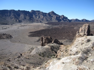
On my last day in Tenerife, I was going to Mount Teide (Pico del Teide). This is a volcano peak and the third highest volcano in the world, after Mauna Kea and Mauna Loa in Hawaii. It stands at 3,718-metre (12,198 ft) and is the highest peak in Spain. It is still active as an volcano but is currently dormant. The last eruption occurred in 1909 from the El Chinyero vent.

This is the highest mountain in Spain.
The volcano is within the Teide National Park and was named a World Heritage Site by UNESCO in 2007.
The park was declared a World Heritage Site in 2007.
I parked the car at the Park HQs near the Roque Cinchado rock formation.

The car park at Park HQs.
It was a sunny clear day and I wanted to get a photo of me next to the volcano.

It was a sunny clear day for my trek.
The Roque Cinchado is a unique rock formation within the Teide National Park and is located about 1700 metres below the summit of Teide volcano. With the volcano in the background, this is a great location for photographs.

The Roque Cinchado rock formation with the volcano in the background.
I was going to be trekking around the rock formations.

Lava rock could be seen around the formations.
I trekked for two hours.

The lava was solid and was clear to see.
After my trek I was hungry and ate my sandwiches in the Park HQs.

I was enjoying my packed lunch sandwiches.
My Colonel phoned me and asked me to return back to the barracks for a secret mission behind enemy lines.
For more information on Teide National Park please visit:
My trip to Malta and Gozo 2012 – part 4
I woke up the next day very hungover after the Christmas 2 celebrations.
Today I was going to visit the Island of Malta by taking the Gozo ferry for a day trip.

It was a good day for sailing.
I was very hungover after last night’s Xmas 2 party and I felt ill on this ferry crossing.
This clip is the Gozo Ferry crossing when it is bad!!! http://www.youtube.com/watch?v=lM1inxAz0_g
And this clip was exactly how my aching head felt: http://www.youtube.com/watch?v=njt8Ae7Dqhc&feature=related
That was exactly how I felt!

Last night Xmas 2 celebrations hangover made me ill on this ferry trip.
My first stop in Malta was the Blue Grotto cave. It is a number of sea caverns on the south coast of Malta.
Apparently this is the most popular tourist attraction in Malta.
The caves combined with the sunlight lead to the water mirroring showing numerous shades of blue.

This cave is very popular with tourists.
I first viewed the caves from above from a viewing platform.

I was impressed by these caves.
I was eager to see the caves from the inside.

I was eager to get a boat out and have a closer look.
From the nearby fishing village of Wied iz-Żurrieq (pronounced weird-is-surriiieeeeuuuu – I think!) it is possible to go on a boat trip to the caves for the sum of eight Euros with no discount for cuddly toys.

The weird plantations in Malta.
It was a 200 metre walk down the road to the fishing harbour of Wied iz-Żurrieq.

The fishing harbour near the Blue Grotto.
This harbour was a tourists trap with loads of restaurants and tour boats.

WW2 defences around the fishing harbour.
The entrance to the harbour had a WW2 defensive position.

The cave complex at the Blue Grotto.
The boat trips coast eight Euros and last 20-25 minutes.

This rock formation looks like a scary face!
I saw all of the caves with some weird formations and phosphorescent colours of the underwater flora.
About 1km from the Blue Grotto is more of the Megalithic Temples of Malta.
Two temples are here, that is the Ħaġar Qim Temple and the Mnajdra Temple. Both were added to the UNESCO World Herritage Site list in 1980.

This temple is on the southern coast of Malta.
Unlike the temple in Gozo, these two temples were shielded from the weather by protective tent constructions.

The temple was a 500 metres walk from Ħaġar Qim temple.
The two temples were 500 metres apart.

Column at the Mnajdra Temple.
The temples were well built and I believe that Balfour Betty were the contractors back then.

The entrance to Mnajdra temple.
It was expensive to view these two temples at a price of nine Euros (no discount for cuddly toys). The temple complex in Gozo was five Euros.

This temple had a protective tent built over it in 2009.
These two temples are thought to be 5600 years old.

One of the rooms inside the temple.
It is not exactly known what the temples were built for, but some research does indicate that cuddly toys were sacrificed here for the Gods.
After seeing the temples, I caught the bus to Valletta. The capital of Malta and another UNESCO World Heritage Site.
The name of the city comes from Jean Parisot de la Valette, who defended the island from the Ottoman invasion in 1565.

The entrance to the Grand Harbour.
The Grand Harbour is heavily guarded with many forts from the centuries of history here. This photograph is Fort Saint Elmo, now the Maltese Police training academy.

The harbour of Valletta.
During WW2, the Italians and the Germans lay siege and bombed the harbour. The siege was broken in August 1942 with Operation Pedestal which suceeded in getting supplies to Malta. In recognition of their fortitude during the siege and air attack, Malta was awarded the George Cross.

The harbour was big and well fortified.
The harbour had many forts and defences around it.

Me looking over the Grand Harbour.
Small fishing ports and ramps were around the harbour.

The charming coastline of Valletta city.
Leaving the harbour I went back inside the city walls to see the city itself. Valletta was built from the 16th century onwards, during the rule of the Order of St. John of Jerusalem (also known as Knights Hospitaller).

The city is a World Heritage Site.
The city was made a UNESCO World Heritage Site in 1980.

St. Johns Co-Cathedral in the centre of Valletta.
The city has signs of old British rule.

Signs of old British rule remains.
Many of the narrow lanes of the city remains untouched over the years.

Very little had changed in Valletta over the years.
I saw this fat cat sleeping on a washing line! How did it balanced itself?

This fat cat was sleeping on the washing up lines.
I had now been sightseeing for over ten hours now and my wee cotton fur feet were aching.

It was getting late.
I was starving so I went to a restaurant before grabbing the ferry back to Gozo.
The next few days, I was going to get my wee cotton fur wet with some scuba diving.
After two weeks in Gozo I flew back to the UK and ready for my next secret mission behind enemy lines.
For more information on sightseeing around Malta please visit:
http://en.wikipedia.org/wiki/%C4%A6a%C4%A1ar_Qim
http://en.wikipedia.org/wiki/Mnajdra
My trip to Malta and Gozo 2012 – part 2
Today I was going to see the sights of Gozo.
My auntie decided that I need to lose some weight and do more exercise. So, I went for a wee walk to the watchtower on the headland just outside Xlendi. My auntie was going to have breakfast ready for me for after my walk.

I decided on an early morning walk to the watchtower.
This tower was built in 1650 by the Grandmaster Lascaris to prevent the Turks from entering this bay.

It was a nice walk.
Restoration work began in 2011 and it is expected that the tower will be made available to the public in the near future.

The watchtower guarding over Xlendi village.
Below the watchtower was many disused salt pans.

Below the watchtower were many disused salt pans.
Gozo beaches are full of salt pans, and the production of sea salt is a major export for Gozo.

It got windy on this piece of headland and I didn’t had my hair clips with me.
I then went to the village for a wee walk along the beach.

It was nice to walk along the beach before breakfast.
It was very quiet at this time.

The local fishing boats are painted colourful.
After breakfast, I took the bus to Victoria – the capital of Gozo. A week bus pass cost twelve Euros and the concession price for cuddly toys is still twelve Euros *HUFF*.
This capital city has a population of just 6000!
First on my list was to see the Citadel or the Citadella as it is known to the locals.

The Citadel was an old small fortified town.
The Citadel is on Malta’s tentative list of future UNESCO World Heritage Sites.

Small alleyways inside the Citadel.
In 1551 a small Turkish force attacked the Citadel, which succumbed with little resistance.

Cactus grows over the walls.
Most of the buildings inside the Citadel were in ruins with cactus growing around them. The church is restored for viewing.

The narrow streets of the Citadel.
The Citadel was a little town inside the walls.
The views from the top were great and the whole of Gozo could be seen.

The view to the North-East.

The view to the East.

The view to the South across the city of Victoria.
After seeing the Citadel, I went to the park for a wee walk.

A very nice photograph that I took of perfect symmetrical trees.
I then took the bus to Xagħra to see the famous windmill and the temple.

Ta’ Kola Windmill is one of the few surviving windmills on the Maltese Islands.
Unfortunately the windmill had lost it sails earlier in the year due to high winds caused by a passing farting swan. So I am told!

Fig trees were everywhere.
The village had a lovely square for a wee cup of coffee and cakes.
The temple was a 5 minute walk away from the town.

This temple is sponsored by Vodafone “The future sounds good!”
The Megalithic Temples of Malta are a series of prehistoric monuments in Malta of which seven are UNESCO World Heritage Sites.

The outer wall of the temple.
The temple was 5500 years old, making them older then the Egyptian Pyramids.
Ġgantija temple was the oldest of the Megalithic Temples of Malta.

This temple is said to be 5500 years old.
The temple is in fact two temples side by side. These two temples were listed as a UNESCO World Heritage Site in 1980. In 1992, the UNESCO Committee further extended the existing listing to include the five other megalithic temple sites.

This is the earliest of a series of megalithic temples in Malta.
It is not known if these temples were used for sacrificing small cuddly toys or sheep.

I was impressed at this temple being older than the Egyptian Pyramids.
Unfortunately, extensive damage to the two temples had occured including graffiti on the walls.

Walkways were recently constructed over the ruins.
Fenced walkways were constructed a few years ago to prevent further damage to the temples by the masses of tourists.

This is in my opinion the best of the Megalithic Temples of Malta.
Unlike the temples on Malta island, this temple is not covered with a semi-tented roof construction.

There was lots to see.
The countryside around the two temples were great for views.

The countryside around the temple were great.
After seeing the temples, I went to the fishing village of Marsalforn.

The harbour of Marsalforn was nice for a wee walk around.
Marsalforn is on the East coast of Gozo and is busier than Xlendi.

This beach was a five minute walk from Marsalforn.
I was tired and wanted to do some sunbathing.

This beach looked great for some sunbathing.
It was mid afternoon, so I decided to relax for the rest of the day to do some sunbathing.

It was very hot here so I was able to top up my furry cotton fur tan.
Whilst I was sunbathing on the beach, a little bugger cleg decided to make lunch of my foot.

This little bugger was biting on me whilst I was sunbathing.
My auntie wanted to swat it, but I didn’t let her and instead asked her to get my camera out of the bag for a photograph.

It was a really painful bite.
It was a really painful bite but I did not cry like a baby. I was glad that I was able to get a really good photograph of the little bugger before I collapse and became unconscious.
The emergency services were called and a vet soon arrived onto the beach to see to me.
I was taken to Mater Dei Hospital, which is the biggest acute hospital on Malta. The hospital had it own specialise cuddly toy department and the emergency oncall team soon attended to my injuries.
Using their lips, the oncall team sucked out the poison from my cotton wool stuffing and sewed me up again with a needle and thread.
The consultant said that I had 5 minutes before the posion would had caused permanent damage to my foam stuffing. It was a close shave!
That night the nurses looked after me, they don’t get to see many monkeys as an inpatient.

My nurse took great care of me.
The next day I was going to continue my sightseeing around Gozo island.
To be continued….
For more information on sightseeing around Gozo please visit:
My travels to Thailand 2010 – part 3
After the riots, I was going to spend a day visiting the old capital Ayutthaya which is 85 km north of Bangkok.
I caught a tour minibus from Khao San Road and was joined by ten other travellers for the day. They were mostly kiwis and aussies. I was the only cuddly toy on the tour bus and as such became the focus of the group because I was different. One of the aussies almost sat on me on the tour bus, he was massive compared to me.
Our first temple was Wat Phu Khao Thong just outside Ayutthaya.

The first temple on the tour was Wat Phu Khao Thong.
I was to visit this temple again in October 2011 during the floods. This temple was mostly flooded then.

This temple was just outside Ayutthaya.
This temple was our first stop and we spent some twenty minutes here.

This temple got flooded in the floods last year.

The top of the temple.
After another ten minutes on the bus, we made it to Ayutthaya Historical Park.

This reclining buddha was very clean and had newly golden cloth on it.
The park was declared a UNESCO World Heritage Site in 1991.

A young Thai girl prints gold stickers onto the buddha.
Ayutthaya was founded by King Ramathibodi I in 1350 and was the capital of the country until its destruction by the Burmese army in 1767.

The city has ten of thousands of Buddha statues.

Student monks on their way to school.

Buddhas were everywhere on show.

Hundreds of buddhas just in this one temple.

With so many temples it is easy to see why this is a World Heritage Site.

I was enjoying the day tour trip.
About midday the tour bus took us to a restaurant for dinner.

I was hungry after the day sightseeing.
The other travellers helped me out of the minibus and the big muscles aussie man cut up my dinner for me.

The 20 metre reclining buddha.

The reclining buddha in Ayutthaya Historic Park.

The feet of the reclining buddha.
After see the reclining buddha, we went to Wat Mahathat.
Here is the famous detached buddha head entangled in roots.

The head of Buddha in Wat Mahathat.
It rises a few centimeters each year due to growth of the roots.

The city of Ayutthaya lays in ruins after the Burmese destruction in 1767.

The old royal palace in Ayutthaya.

I was out of breath climbing these stairs.

I wanted to get to the top of this staircase.

I was praying for strength and guidence.

I prayed for good karma and luck.

These statues had their heads stolen by thieves.

Admiring this statue.

I was praying at this Buddha statue.

Getting myself blessed at a temple shrine.
The next day I was going to do some scuba diving.
To be continued….
For more information on Ayutthaya Historical Park please visit:
http://en.wikipedia.org/wiki/Ayutthaya_Historical_Park
Details of my trip to Ayutthaya in 2011 is here: https://britisharmysgtmonkey.wordpress.com/2011/10/12/my-travels-in-thailand-2011/
My trip to Iceland 2012 – part 2
Today I was going to see the countryside on what is known as the Golden Circle Classic Tour.
The tour includes a visit to Thingvellir National Park – the site of the oldest existing parliament in the world. Then was going to see the Gullfoss, Iceland’s famous waterfall and finally to the Geysir area, a geothermal field where hot springs are in abundance, geysers explode and pools of mud bubble.
My first stop of the tour was to see Thingvellir National Park (Þingvellir). This is the site of the oldest existing parliament in the world and is an UNESCO World Heritage Site.

The mountains in the distance still had snow on.
The park is the site of a rift valley that marks the crest of the Mid-Atlantic Ridge.

The park marks the crest of the Mid-Atlantic Ridge.
The Mid-Atlantic Ridge is the where the continential plates of America and Europe meet.

The valley formed by the Mid-Atlantic Ridge.
Lava is seen here that had set into the landscape.

Lava thousands of years old is seen all around Iceland.
I was enjoying the day out.

The views were amazing.
Next I went to Gulloss the waterfall.

The water spray turned to ice on the far side of the waterfall.
Gullfoss is one of the most popular tourist attractions in the country.

I stayed behind the safety fence.
After the waterfall I was off to the Geysir area. Due to the high rate of volcanic activity in Iceland, it is home to some of the greatest geysers in the world.
Geysers and hot springs that erupts into jets of hot water and steam.

The water is said to be 80 degrees.
The Great Geysir which first erupted in the 14th century, gave rise to the word geyser but this geyser rarely erupts these days.
The nearby Strokkur geyser erupts every 5 to 8 minutes to a height of some 30 metres.

The water erupts up to thirty metres in height.
The eruptions are every 5 to 8 minutes.

The water spurts out every 5 to 8 minutes and to a height of thirty metres.
After seeing the geysers, I went to see the inactive Kerið volcano crater.

This volcano is inactive.
This volcano has not errupted for 3000 years.

I was hoping this volcano did not erupt soon!
After seeing the volcano, I went to the church at Skálholt.

This church is popular with tourists.
The church at Skálholt is relatively large in comparison to most Icelandic churches.

The light reflected off the walls.

The light from the stained glass windows gave a spooky feel.
I headed back to Reykjavík to check out the Icelandic girls in the nightclubs.
To be continued….
For more information about Iceland please visit:
Me packing for my trip to Iceland
This weekend I am off to Iceland.
YIPPPPEEEEE……

A map of Iceland.
After a hard few months working at the barracks beasting my new recruits, I need the break.
This is a picture of me packing for my trip. I am taking a lot of cold weather clothes as it is brrrr in Iceland.

Me packing for my trip to Iceland.
I will be scuba diving in Silfra crack in Thingvellir National Park – a UNESCO World Heritage Site. This dive site is famous for it 40 metres plus visability and even 100 metres plus visability on good days. The site is the joining of the two continental plates, the American and Eurasian continents. It is famous for it rock formations and visability and one of the best dive sites in the world and I am going to be the first cuddly toy scuba diving it.

This is the dive site that I am going to next week.
I will also be relaxing in the hot springs to relax my aching cotton fur feet after my long distance walk a few weeks ago.
Whilst I am away, please remember that we have two competitions running at the moment.
The “Where’s monkey” competition is here: https://britisharmysgtmonkey.wordpress.com/2012/03/23/competition-wheres-monkey/
The “10,000th hitter” competition is here: https://britisharmysgtmonkey.wordpress.com/2011/10/31/competition-the-10000th-hitter/
Amazing prizes can be won in each of these these competitions so get entering.
When I am back on the 22nd April, I will be very busy with my Local Elections campaign in Edinburgh where I am contesting for a seat on Edinburgh Council. Please read through my policys also on this website and if you agree with my “piggyback to work” scheme as an alternative to the Edinburgh trams farce then please vote for me.
As I said, that week – I will be busy campaigning on the streets of Edinburgh, so I won’t be able to put my Iceland photos up until after the elections on May 3rd.
If you live in Edinburgh and are willing to volunteer your time to help us with the elections campaign, please email the webmaster on our usual email address. We can hand you some Monkey Party leaflets for you to distribute.
Scotland long distance walks: Fife Coastal Path – part 1
Now that I had been in Scotland for eight years, I decided to tackle some of the long distance walks of Scotland. It is my plan to walk the famous West Highland Way (151 kms) sometime this summer which takes in the scenery of Glencoe and Loch Lomand. Eventuatally I am going to walk the Cape Wrath Trail (326 kms). The trail is mostly unmarked and passes through remote countryside that is extremely wild and rugged terrain. This trail is said to be Britains’s toughest walking route.
This website lists the long distance walks of Scotland:
http://www.walkhighlands.co.uk/long-distance-routes.shtml
To make the most of the heat wave that we are experiencing in Scotland at the moment, I decided on a mini long distance trek this week. I decided to do the Fife Coastal Path from North Queensferry to St. Andrews (98 kms). My plan was to be self sufficent in carrying my own gear and camping out in the wild – no hotels or B&B. I had to carry five days supply of rations and water as well as my camping gear. I left on Sunday and came back yesterday. So it took me four days. I had planned on five days. So I was able to walk within my plan, not bad for the small cuddly toy that I am.

A map of the route.
This photograph shows my packing. The packed weighed 25kgs. That is 100 times my own body weight! When I came back yesterday it was 16kgs.

My kit consisting of five day supplies.
Large water bottles are not included in this picture which made up the bulk of my weight. Rations were compact style purchased from camping shops and army surplus stores. I only packed four days of food rations as I intended on eating pub meals at the East Neuk fishing villages.
The walk starts in the small village of North Queensferry.
The village takes its name from Saint Margaret of Scotland, the wife of King Malcolm III of Scotland. She established the village to ensure there would be regular ferry crossings across the Firth of Forth for the benefit of pilgrims travelling to St. Andrews.

The Fife Coastal Path starts in North Queensferry under the famous Forth Rail Bridge.
The Forth Rail Bridge was opened in 1890 and is a total length of 2,528 metres. The bridge connects Edinburgh to Fife over the Firth of Forth.
The bridge was nominated as a UNESCO World Heritage Site last year and is now awaiting approval on the list.

It was a hot sunny day.
A sign next to a well marked the start of the path.

A sign marked the start of the Fife Coastal Path.
The well was used by travellers and horse carts in the old days.

The start of the Fife Coastal Path.
I was eager to start the walk.

With my suncream on, I was ready.
As I progress up the path, I looked back onto North Queensferry and the bridge.

The bridge shadows over the village of North Queensferry.
I had a long way to go and a heavy bag!
To be continued….
For more information on this leg of the Fife Coastal Path please visit:
http://www.walkhighlands.co.uk/fife-stirling/n-q-burntisland.shtml
My trip to Egypt in 2010 – part 3
For my last two days in the Sinai, I was going to be trekking in the Sinai Mountains. My plan was to climb Mount Sinai overnight so that I was on the summit for the sunrise.
Mount Sinai is a 2,285-metre (7,497 ft) high mountain in the Sinai Peninsula.
According to Jewish and Christian teaching, Mount Sinai was the place where Moses received the Ten Commandments.
Dressed in traditional Bedouin robes, I was ready for the ascent.

I was ready for my trek.
For the ascent of the mountain, I took the Siket El Bashait path. This path takes about 2.5 hours on foot. However this path is very popular with tourists and many tourists climb the path though camels. One have to becareful on this path as it is very easy to get run over by a camel with a fat tourist riding it. As I said, this path is VERY popular and is at times, ridiculous with the number of camels and trekkers.
The usual ascent is overnight, thus getting to the summit for the sunrise.

It was great!
The mountains of the Sinai Peninsula glows red under the sunrise.

The mountains glowed red under the sunrise.
I was glad I made it up to the summit in time for the sunrise.

The views were great.
I was able to see all across the Sinai Peninsula.

The views were great!
A Greek Orthodox Chapel is at the top of Mount Sinai. This chapel was built in 1934 and is not open to the public.

The little chapel at the top of Mount Sinai.
The descent was done by the steeper, more direct route Siket Sayidna Musa path.

The descent was by carved out steps in the rock.
This path is made up of the 3,750 “Steps of Penitence” in the ravine that leads to the monastery at the foot of Mount Sinai.

The monastery as seen from Mount Sinai.
The monastery at the foot of Mount Sinai, is St. Catherine’s Monastery. The Greek Orthodox monastery is a World Heritage Site as listed with UNESCO.

I went inside the compound.
It is claimed that this is oldest working Christian monastery in the world.
When I got back to Dahab, I went sunbathing for the last time before flying back to the barracks for work.

Soaking up the rays.
It was good flying to Egypt during the UK winter. Flights are cheap and direct while sunshine is granted.
For more information on Mount Sinai please visit:
http://en.wikipedia.org/wiki/Mount_Sinai
http://en.wikipedia.org/wiki/Saint_Catherine%27s_Monastery,_Mount_Sinai
My trip to Cyprus in 2010 – part 4
Today I was going to drive to Paphos on the West coast of Cyprus. The town of Paphos is a World Heritage Site listed with UNESCO.
In Greco-Roman times Paphos was the island’s capital. The remains of the governor’s palace with it mosaics is the main tourist attraction here.
However, today I was going the see the castle, the harbour and the Tombs of the Kings.

The castle was on the harbour edge.
When I got here, it just started to rain! Rain in Cyprus in the middle of the summer!?!

The castle was just next to the harbour.
Apparently the British used this castle to imprision people!

The harbour was used by the local fishermen.
Despite the rain, I went to a wee walk around the harbour.

The harbour was very nice for a wee walk.
It was very quiet on the quayside.

So that is where I locked my bike to eight years ago!
After a coffee on the quayside, I went to the Tombs of the Kings.

These underground tombs gave me the creeps.
The tombs have been known and casually explored for centuries but it was in the 1970s to 1980s that they were excavated.

It was late afternoon when I arrived and very few tourists at this time.
The tombs date back to the 4th century BC.

The site is quite large with about 100 tombs in all in 8 or so complexes.
It is thought the tombs are the burial sites of Paphitic aristocrats.

This was someones grave!?!
The tombs were carved into the rocks.

The tombs was carved into the rocks by hand.
However some of the tombs were feature Greek style Doric columns.

This tomb must had been for someone very important or rich!
It was nice looking at these tombs but one must remember these tombs are actual burial places.

I went underground in one of the tombs.
I had decided that I am going to write a letter to Edinburgh City Council asking for the construction to begin of my very own tomb to be built on the grounds of Edinburgh Castle. Afterall, I am a very important cuddly toy.

My own tomb will be constructed like this in the centre of Edinburgh for all to see.
The next day I was going to be trekking in Troodos Mountains.
For more information about Paphos, Paphos Castle and the Tombs of the Kings please visit:
http://en.wikipedia.org/wiki/Paphos
http://en.wikipedia.org/wiki/Paphos_Castle
http://en.wikipedia.org/wiki/Tombs_of_the_Kings_(Paphos)
http://www.sacred-destinations.com/cyprus/paphos-tombs-of-the-kings.htm
To be continued….
My visit to Notre Dame Cathedral in Paris
A few days ago I posted my Morocco trip blog with the Berbers desert tribe. Whilst on my flight back to the UK following that desert trek, I had to change planes at Paris CDG airport. I had eight hours stopover so I decided to take the train into the centre of Paris.
It was a misserable wet day in Paris, so different from sunny Marrakesh where I took the flight to Paris from.
The airport fast train stop in the subway station just on the banks of the River Seine. I was at the west end of Notre Dame Cathedral.

The Western facade of Notre Dame Cathedral.
Notre Dame Cathedral is widely considered one of the finest examples of French Gothic architecture in France and is a UNESCO listed World Heritage Site. It was completed in 1345.
In 1991 a major ten year restoration program began, so the cathedral is in top form for any potential travel photographers. It was a shame that I wasn’t able to take photos under a clear sky.

I wish that I had my brolly with me!
Whilst I was looking around the cathedral I kept my eye out for a sighting of the famous hunchback bell-ringer Quasimodo but I never saw him!

The cathedral is on the banks of the River Seine.
After a mulled wine on the banks of the Seine I took the train back to CDG airport and back to the UK.
After my Moroccan desert trek and my wet day out in Paris, I was very dirty so my foster Auntie put me into the washing machine for a spin.
For more information about Notre Dame Cathedral please visit:
